Isolated rain chances are possible, slightly better chance late on Memorial Day.
FORECAST HIGHLIGHTS
- ISOLATED STORMS: Spotty activity this afternoon, watching for storms tonight
- MEMORIAL DAY: Front brings better shot at showers & storms
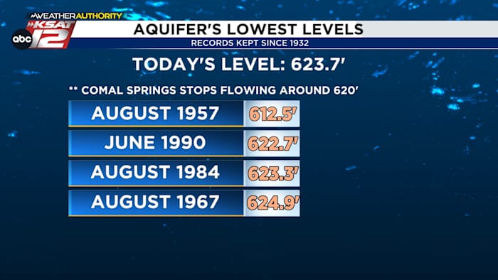
- AQUIFER DROP: We continue to see some of the lowest levels in decades
FORECAST
You don’t need me to tell you that we need rain and we need it now. Thankfully, we do have some opportunities in the short-term forecast.
ISOLATED STORMS TODAY
A few pop-up storms will be possible during the afternoon. Rain chances sit at 20% today. Otherwise, it’ll be partly cloudy and hot. Highs, once again, reach the upper-90s. The one big difference today is that humidity is back. That means heat index values will top 100° for several hours this afternoon.

WATCHING FOR STORMS TONIGHT
There is a small chances that storms could gather to our north this evening and make a run at South Texas tonight. The odds of this are low, but worth watching.
MEMORIAL DAY WEEKEND
The main takeaway here is that most of the weekend will be spent dry. It’ll be hot and humid, too. A small storm chance shows up Sunday afternoon (20%). This is mainly for those west of San Antonio. As for Memorial Day itself, we are still expecting a frontal boundary. The front, however, likely holds off moving into the area until late in the day. As a result, our best rain chances now look to be Monday night. Scattered storms will be possible.

AQUIFER/SPRINGS CONTINUE TO DROP
A quick check of aquifer and spring levels this morning show some of the lowest numbers seen in decades. While we are still nowhere near the lows of the 1950s, levels are the lowest we’ve seen since 1990.

QUICK WEATHER LINKS
- WATCH LIVE: Doppler Radar
- Hourly and 10-Day Forecast
- Download FREE KSAT Weather Authority App: Up-to-date forecast information and livestreams from trusted local meteorologists.
- KSAT Connect: Share your weather photos.