Scattered showers and storms will spread east toward San Antonio this afternoon.
FORECAST HIGHLIGHTS
- SCATTERED RAIN: Arrives by afternoon, could affect evening commute
- DRY WEATHER TAKES OVER: A much drier pattern takes hold this weekend
- COOL MORNINGS: Mornings will dip into the 50s Saturday/Sunday
FORECAST
An area of low pressure combined with a cool front will give us a decent chance for showers and even a few storms this afternoon and this evening. This may affect after school practices and the evening commute.
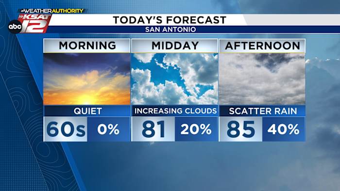
RAIN CHANCES TODAY/TONIGHT
The morning hours will be quiet, with passing clouds and comfortable temperatures. By midday, storms may start to fire along the Rio Grande, with rain spreading east during the afternoon. While the best odds for substantial rainfall will be south and west of San Antonio, scattered activity is possible across the metro (40%). There is a low risk of severe weather. Rain chances continue through roughly midnight, before winding down.

LOW HUMIDITY THIS WEEKEND
On Friday, we’ll be on the backside of the area of low pressure. That’ll give us gusty northerly winds and not-so-hot temperatures. A stray shower can’t be ruled out, but any rain would be brief and light.
For both Saturday and Sunday, mornings will be COOL. We’ll start in the upper-50s and end up in the 80s. Mother’s Day looks beautiful.

GET READY FOR HEAT
As nice as the weekend will be, next week is looking hot. By Tuesday, San Antonio is forecast to reach the mid-90s. Upper-90s are possible by midweek. The area’s typical hotspots (Del Rio, Cotulla) could be looking at triple digits. Unfortunately, the long-term forecast calls for rain-free conditions.

QUICK WEATHER LINKS
- WATCH LIVE: Doppler Radar
- Hourly and 10-Day Forecast
- Download FREE KSAT Weather Authority App: Up-to-date forecast information and livestreams from trusted local meteorologists.
- KSAT Connect: Share your weather photos.


iOfw RqBFza lqTsGXtl