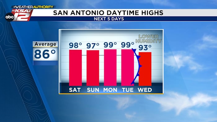
Lots of heat this weekend and early next week. Thankfully, a front will cool us down some by midweek.
FORECAST HIGHLIGHTS
- HEAT INDEX 102°+: It’ll be humid all day, pushing heat indices above 100°
- FEW STORMS SATURDAY: Isolated storms possible
- FRONT TUESDAY: Lower humidity & temps by Wednesday
FORECAST
We’ve now experienced three days in a row of record heat. We’ll have the potential to tie another record today and then the streak should come to an end. THANK GOODNESS!
THICK HUMIDITY TODAY
Humidity levels continue to increase, making for muggy conditions. We’ll see morning clouds, followed by some sun this afternoon. Highs, like yesterday, will reach the upper-90s. That’ll translate to heat index values in the range of 102-104°. A stray storm, mainly in the Hill Country can’t be ruled out.

ISOLATED STORMS SATURDAY EVENING
Saturday will be hot and humid, too. The only difference is that atmosphere will be a bit more unstable. Isolated storms will be possible in the Hill Country and along the Rio Grande. There’s an outside chance that these storms could move east toward San Antonio Saturday night. Otherwise, it’ll be partly cloudy. Sunday should look very similar.

A FRONT?!
Yes… but, know this time of year our cold fronts aren’t particularly strong. That said, we’ll enjoy some lower humidity and lower temperatures by Wednesday. Morning lows will return to the 60s, while afternoon highs return to the low-90s.

QUICK WEATHER LINKS
- WATCH LIVE: Doppler Radar
- Hourly and 10-Day Forecast
- Download FREE KSAT Weather Authority App: Up-to-date forecast information and livestreams from trusted local meteorologists.
- KSAT Connect: Share your weather photos.