Isolated activity today, a few more showers along a front tomorrow.
FORECAST HIGHLIGHTS
- ISOLATED STORM: Possible today, mainly south of SA
- SHOWERS THURSDAY: A few showers are possible as a front moves through
- DRY MOTHER’S DAY WEEKEND: Cool mornings, warm afternoons
FORECAST
Good morning! While it’s been a busy weather stretch, we still haven’t seen enough rain to climb out of drought conditions… at least not in San Antonio. There are a few more chances for rain today and tomorrow.
ISOLATED STORM TODAY
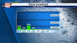
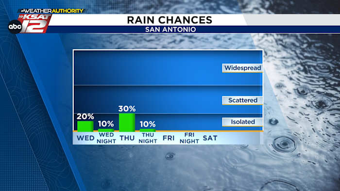
Storms developed from Laredo to Corpus Christi overnight and they are currently moving up the Texas coast. That activity will quickly move away. In the wake of those storms, a few isolated pop-ups may re-develop this afternoon (20%). Should that happen, severe weather would be possible. This is mostly for those south of I-10. The Storm Prediction Center does have this area highlighted for a chance of severe storms.

SHOWERS THURSDAY
Upper level energy combined with a front should bring a slightly better chance for rain tomorrow (30%). For San Antonio, it’ll likely be in the form of a few showers during the afternoon. Farther south, storms may fire along the front, with severe weather possible into Thursday night.

DRY & BEAUTIFUL MOTHER’S DAY WEEKEND
Low humidity takes over this weekend, making for cool mornings and warm afternoons. It’ll be rain-free.

HOT & DRY NEXT WEEK
Trends are calling for 90s next week, while rain stays out of the forecast. This could worsen drought conditions.

QUICK WEATHER LINKS
- WATCH LIVE: Doppler Radar
- Hourly and 10-Day Forecast
- Download FREE KSAT Weather Authority App: Up-to-date forecast information and livestreams from trusted local meteorologists.
- KSAT Connect: Share your weather photos.
�